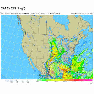
Thom and I are considering options for tomorrow....and, I must say, I think the pattern looks a bit better tomorrow than the pattern we had today.
There is a wedge of high dew point temperatures and CAPE, with, according to the WRF-NAM, little CIN, from southeast Oklahoma through extreme eastern KS to the northeastern third of Kansas....underneath very decent 500 mb flow. In fact, the surface wind to 500 mb crossover is forecast to be much better in those areas than the best we had today. So good, that the forecast 0-3 km SREH values are very enticing...where they are coextensive with the better instability values.
I plotted forecast soundings and hodographs for that area, and there are some striking anticyclonic loops in the lowest 3 km over se KS and up through the Topeka area...and also down into se Oklahoma. The soundings have a very steep lapse rate in the EML which explains why the forecast sbCAPE values are more striking for those areas tomorrow than the same surface temps and dew points produced today in parts of KS.
I think we'll be rargeting the area east of a Topeka-Emporia-Tulsa arc tomorrow afternoon. I'd rather not go down to the tropical rainforested hills of se Oklahoma, but I will if the pattern resolves out better in the morning models and obs; so that arc may spread south of Interstate 40.
Right now it's a go for us. The prospects seem much better in those areas tomorrow than anything we had today, and we saw interesting storm structure today.
Blog Archive
-
▼
2011
(34)
-
▼
May
(34)
- May 30: Homeward
- May 29: Cheyenne Ridge area of extreme se Wyoming/...
- May 28: Two Possible Targets in KS--Went to Color...
- May 23: Wall Cloud/Brief Tornado -- Okeene, Okla...
- May 24: Canton Lake/Fairview Tornado--Elephant Tr...
- May 27 -- Central and North Central OK
- Grove OK Tornado May 22, 2011 -- Very Brief Glimps...
- May 22 -- First Grove Tornado
- May 26: National Weather Center
- First Hand Account of Joplin Tornado by Roger Hill...
- Update on Tornadoes: May 22 and May 24
- May 25: Holding Steady in Oklahoma
- May 24: Canton/Fairview Tornado
- Frist Cells---
- May 24: Central Oklahoma
- May 23: At least ten funnel clouds/possible tornado
- May 23: West Central Oklahoma
- May 22: Joplin
- May 22: Stovepipe Tornado, 2 Funnels, and Possible...
- May 22: Stovepipe Tornado, 2 Funnels, and Possible...
- On the way to Nowata, OK
- May 22: ne Oklahoma or north Texas? It's ne Oklah...
- May 21: Convective Initiation Soon....and Giving U...
- May 21: Into Southeastern KS
- Preliminary Target for May 21--Southeastern Third ...
- Forming Wall Cloud--Three Storms, Briefly Supercel...
- Organizing Supercell
- In Great Bend at 3:53PM CDT...
- A Mess of Storms Today: No Significant Focus, and...
- Several energetic storms...
- Onto west-central Kansas
- Onto the Great Plains
- First Day Target --- More or Less Unchanged
- Storm Chase Trip 2011 -- In to the Great Plains, M...
-
▼
May
(34)


