
May 29, 2011
May 30: Homeward
Well, for various reasons, I have decided to call it a chase for this season. Our chase was successful during this nearly week-long period when the synoptic-scale patterns were favorable. We also made some bad navigational and tactical errors. More on that when I have time to contemplate the last ten days.
May 29: Cheyenne Ridge area of extreme se Wyoming/ne Colorado

5:13 PM MDT Update...Sitting near I76 south of Fort Morgan or so, awaiting whatever might happen. Right now, not much.
The target seems too obvious...and I hope I am not deluding myself because I am in Denver right now. The models paints a very favorable picture for both supercells and a possible tornado along the Cheyenne Ridge this afternoon. Ahead of the deep trough coming into the Four Corners area under 40 to 50 knot 500 mb flow...the RUC has a surface cyclone correctly initialized this morning. During the day this intensifies and channels strong east southeast flow into Colorado bringing really high dew points for this part of the Plains into ne Colorado and then up the Cheyenne Ridge. Will 55 to 60 F dew points actually make it into this area, which currently has 40s? My guess is yes....as the foggy air all over this area currently has 50s dew points.


Upstream in the surface flow in KS are the 60+ dew points in southeast flow moving this way. The model takes the surface low northward and centers it in north-central Colorado this afternoon and I can't believe my eyes that it has surface southeasterly winds of sustained 20 knots or so over the region, and with a great angle with respect to the Cheyenne Ridge.
Throwing caution to the winds, because as soon as I point this out, the next run will evaporate it, I see the RUC breaks out precipitation there and has what looks like a supercell east south east of Cheyenne. As others have pointed out that starts out in the mountain convection around 20 UTC or so, and has a very good look around 22 UTC. I plotted a sounding and hodograph from the RUC for that location for 0000 UTC. Those are to the right.
While I'd like to see more turning in the hodograph in the lowest 3 km...it's pretty good. The sounding says that LCLs will be low too, but there are some CAPE-robber qualities in it. That elevated inversion was there in all the forecast hours, but was very strong in the initialization and systematically weakens. Finally, yes, this is all contingent on the fog clearing out. Not the initiation in the mountains though....that will happen. I'll wager the soundings evolve sort of like the one I have below, because the fog will have cleared out.
May 28, 2011
May 28: Two Possible Targets in KS--Went to Colorado...and Bust
 10:05 MDT Update: After sheparding Thom to the Tulsa Airport, I hooked up with Scott Landolt and company....targeting Colorado.
I decided to abandon my target areas because of tremendous capping (the warm air aloft mentioned below)....but much to my dismay...one of them would have had me reasonably close to the storm in Kingfisher County, Oklahoma, though, truthfully, I would have been further west and probably would never have gotten back in time for....what? Frankly, that storm looked good on satellite, but never did have a stunning look on radar. But I digress....
....decided to play that ever shimmering target of the Palmer Divide, which once again, when I got there, lost its shimmer. Will the Palmer Divide ever, ever produce a decent storm as advertised. I realize that rotating storm did develop a way down south...but what we were seeing along I70 looked to me to be layered clouds associated with forced lift of pretty stable air north of a warm front in the warm advection area.
I am certain enough about an early exit for me to have booked a flight for Monday. True, eastern Wyoming or ne Colorado beckons tomorrow....but I am not going to go way northeast on Monday, and after that all things go down hill and, frankly, the weather pattern in California looks to be more interesting later in the week.8:15 AM CDT. Awaiting the 12 UTC RUC. But the two other plays I see (besides eastern Colorado) are along the outflow boundary/quasi-warm front south of I70 (sort of north of Emporia and west to east from there, but mostly east) and the upslope area along the KS-OK border.
There is a very warm layer, or cap, pushing out from the desert Southwest at around 10000 feet. That will make storm initiation a real problem. But the models have a real moisture surge underneath that back towards the west around the mesolow in Oklahoma, and adequate moisture along the outflow boundary further north too. With lots of heating, getting storms to initiate may not be impossible...and if they can move back into that deep moisture, then a supercell or two is not out of the question.

I just dropped Thom at the Tulsa airport...and will be attempting to link up with Scott Landolt, Daniel Porter and Cameron Redwine later on.
May 23: Wall Cloud/Brief Tornado -- Okeene, Oklahoma
This is a short video showing an impressive wall cloud/lowering near Okeene, Oklahoma on May 23, 2011. You'll see a brief tornado, we think, on the east side of the wall cloud as it approaches the road. The view is looking north. The video is shot by a point-of-view camera with no zoom, and the focus set at infinity. Thus, the wide angle makes everything appear very small.
May 27, 2011
May 24: Canton Lake/Fairview Tornado--Elephant Trunk/Sinuous Funnel Stage
Again, this is the download from our HD point of view camera. It cannot be zoomed. I will download footage from my digital video cam when I return home.
The Canton Lake storm was rated EF3. However, we saw its first stages (below) and this stage. There must have been translucent connections to the ground for the first stage and a dramatic multiple vortex or suction vortex with this stage in order to account for the damage. The visual evidence is not compelling from this video.
The Canton Lake storm was rated EF3. However, we saw its first stages (below) and this stage. There must have been translucent connections to the ground for the first stage and a dramatic multiple vortex or suction vortex with this stage in order to account for the damage. The visual evidence is not compelling from this video.
May 27 -- Central and North Central OK
 6PM CDT update: we are definitely in moist flow up here in Guthrie. Unfortunately, the stratocumulus field is squashed. The inversion is holding, at least to this point. Models still suggest something happening between 7-8PM CDT....with sunset around 8:30 PM...not much time to observe a storm...and we do not chase at night.
_____________________________
A warm front/dry line/cold front triple point should move into the area west of Oklahoma City this afternoon. There is more than adequate shear for supercells. Here's our target.
Some of the issues include whether adequate deep moisture will get back into the target area if the triple point is there. The models are suggesting that convection should outbreak in the area of slightly southwest of Oklahoma City to Guthrie to Ponca City and slightly eastward in discrete cells at around 4PM local time.
We are currently (1:54 PM CDT) in Gutrhie, Oklahoma in Rick's Fine Chocolates and Coffee Shop. Besides the great coffee, there is a good wireless connection here.
May 26, 2011
Grove OK Tornado May 22, 2011 -- Very Brief Glimpses of Stovepipe
This was very frustrating...the tornado then evolved into a fat stovepipe shaped thing to the left (east) of the road, about 4 miles away. But the trees only allowed brief glimpses. Remember, the Point-of-view camera has no zooming feature.
May 22 -- First Grove Tornado
This is from our windshield mounted camera. No zooming possible and no rotating field of view (beyond 20 degrees or so). We were in forest and hills...the tornado is right on the road directly ahead of the camera and then slightly to the left of the road. We were desperately trying to find a place to stop with an unobstructed view.
May 26: National Weather Center
Thom and I are taking this down day in Norman, OK. He's never seen the National Weather Center (dubbed the "Intergalactic Weather Center" by Chuck Doswell). We'll also visit with Chuck and Vickie, Mike Foster and others, and perhaps see a movie. Tomorrow there is a risk of supercells in central Oklahoma....so we are staying in place. Thom is changing his outbound flight to Tulsa or Oklahoma City.
May 25, 2011
First Hand Account of Joplin Tornado by Roger Hill, a Colleague of Mine
Adding pictures to older Blog Entries...be sure to check below
."...Well, might as well throw in what happened to us this day, but PLEASE understand what happened was TOTALLY unintentional.
We started the day in Tulsa and drifted north into southeast Kansas. Was on the pile of junk cluster of cores spewing outflow from Parsons, through far southeastern Kansas. Several new cells formed south of the outflow boundary from the storms north of Columbus, and as they developed, they crossed into cold air, spun for a few minutes and then became hailers. Near Crestline, KS we encountered a cell that produced near baseballs on us. It had a nice wall cloud, but quickly crossed into the cold outflow air and weakened. Seeing the storm that would eventually become the Joplin wedge producer develop, we moved east into Joplin, with intent to drop onto 44. We came into town on Mc Arthur Dr, and then turned south onto 71B. This was about 20 minutes before the tornado formed. Running low of fuel and many tour guests in need of a restroom stop, we stopped on 71B. I just happened to look at radar and see the storm right turn along the OFB and develop a strong hook. We ended up blowing off the gas/restroom break and headed south to get out of the way in case the supercell was producing a tornado.
As we drove south, the notch was becoming visible as rain curtains were wrapping intensely on the east side of the now wedge. We were directly in the path of this monster and I knew we were in serious trouble if we didn't get out of the way. We were now crossing 44 Business and heading south toward the I-44 corridor and trying desparately to get out of town. Traffic was oblivious to the situation developing, and there were NOT any tornado sirens to be heard! As we crossed 15th street, numerous power flashes occured just to out west. People were walking around and not paying any attention to what was going on. We yelled out to take cover NOW, and several laughed at us. Two vehicles were next to us at a traffic light and we told them what was going on and they totally ignored us. As we crossed 20th street headed south, things got worse than I have ever witnessed. Intense rapid rotating rain curtains were only a few hundred yards west of us, and all power went off. Traffic lights ceased working and we knew we had to take things into our control and blow threw them. We weaved in and out of cars with our flashers on as vehicles stopped in the middle of the road and watched. Cars were going northbound and I shutter to think what happened to them. We honked, yelled out to any vehicle or person WALKING up the street to take cover and then had to get south. As we approached 29th street rain curtains blew from southwest to northeast and chunks of debris started falling as continued power flashes were occuring extremely close to us. Westerly winds picked up to at least 80 mph as we weaved in and out of traffic, finally approaching the interstate. We turned east of 44 and then south on 71. One of the most intense moments of my life and shows how quickly things can evolve when you least expect it! Jeff P's video was extreme and he was not far from us, but he was there intentionally. I was not.
Later we witnessed the cone near Southwest City, and then a stovepipe west of Siloam Springs that damaged a bunch of mobile homes. Absolutely insane day, one I will never forget.
An absolutely horrific experience for the poor souls of Joplin. A good friend of mine was the manager of the Pepsi plant there and it was totally leveled, with a few of his friends now deceased. ...."
Update on Tornadoes: May 22 and May 24
May 24, 2011 - Canton Tornado
 The Canton tornado (picture reposted here) of May 24, 2011 has been rated an EF3 tornado. We also have learned that the first video we took (to be posted later) may have been the tornado that caused the most damage.
May 22, 2011 - Joplin Tornado
We have included a map showing the track of the Joplin tornado, now rated EF5. The red arrow shows the track of the tornado based upon NWS surveys. The black squares represent our position (by GPS) at 5:48 and 5:50 PM. The tornado first formed at 5:41 PM and lifted at around 5:53 PM. At the time it lifed, we were stopped by the heavy precipitation and hail in the hook curling around the storm's southside. If we had continued through the hook, we likely would have had a very close encounter with the tornado at about the time it was dissipating.
More sobering for us, is that we waited about 10 minutes in Miami, OK before moving northeastward, photographing a funnel cloud. If we had not done that, the hook would have not been crossing the freeway when we got to Joplin...and, worse, we likely would have been well into the city of Joplin when the tornado was in the city.

May 25: Holding Steady in Oklahoma
Today is a down day for us.
We've had a change in plans. Although there is a reasonable pattern for severe storms in eastern Wyoming and the Nebraska Panhandle tomorrow....there is a far better risk for organized convection and supercells in the eastern half of Oklahoma on Friday. Right now, the plan is for Thom to change his flight to Oklahoma City or Tulsa for Saturday morning. We'll make a final decision about that tomorrow morning. But tonight and perhaps tomorrow we'll be staying in Norman.
This gives Thom a chance to see the National Weather Center (aka Intergalactic Weather Center) and us a chance to visit with Chuck and Vickie.
Meanwhile, we had an illustration yesterday of why Tornado Warnings, even if very timely, don't work very well anymore out here. The server at the Starbucks in Enid yesterday told us that when she hears a Tornado Warning she heads outside to check the sky. Mostly, that would be OK, of course, because most tornadoes are small, and the tornado warnings are kind of general enough...in cities they turn on the sirens to warn the whole town.
In the case of Joplin on May 22, the tornado was so large and fast moving that any action besides taking cover was probably fatal. I am trying to get permission to repost what one of my storm chase colleagues related about his experiences in Joplin that day to illustrate.
May 24: Canton/Fairview Tornado

We were off to a vigorous cell about 70 miles southwest of Enid. We'll post some pictures right away of the small elephant trunk tornado that formed on that storm as it approached Canton and Fairview, OK.
Later, we sped eastward to get ahead of more supercells passing across I35 and managed to see the mesocyclone left behind from the Guthrie tornado...and may have seen a wedge tornado wrapped in rain near the town of Hominy. More as time permits.
Later, we sped eastward to get ahead of more supercells passing across I35 and managed to see the mesocyclone left behind from the Guthrie tornado...and may have seen a wedge tornado wrapped in rain near the town of Hominy. More as time permits.


May 24, 2011
Frist Cells---
we are leaving Enid. There is a very healthy looking cell north of I40 moving into west central Oklahoma.
May 24: Central Oklahoma

We are currently in Enid, Oklahoma. The students reading this blog will recognize this morning's Oklahoma City sounding as an example of the so-called "Loaded Gun" sounding. In fact, the sounding will be altered by afternoon not only by surface heating but by increasing dew points. This makes the potential for this sounding even more significant.
The morning's surface map has many incredients in place...a triple point in south-central KS....with a dry line extending south. A warm front moving through Oklahoma into southern KS. However, the models portray some forecast issues for foci. One model moves the triple point north and would have the risk further north...while another model has the best play of incredients in the southern portion of Central Oklahoma.

The OKC and Tulsa Metropolitan areas will be threatened this afternoon.
This is fresh after the awful destruction that the Joplin tornado caused. The death toll is over 150 now, and the indicaitions are that this may have been one of the most destructive tornadows in the record of the National Weather Service.
May 23, 2011
May 23: At least ten funnel clouds/possible tornado
 |
| Thom taking a picture of what might be a developing tornado near Kingfisher |
Thom and I were eating lunch in Fairview OK (about 60 miles northwest of Oklahoma City) watching the first Fairview storm develop. It was already rotating soon after it had an anvil, complete with an elevated horseshoe base. Right away, it was odd....on the southeast side of the updraft tower was a very pronounced laminar funnel...not from the rain free base. There were four other sinuous funnels, elevated bases...but with large extension from the forward flank tower. We saw yet another funnel cloud with this storm after it backbuilt about an hour later, and a tornado warning appeared a short time after.
 |
| Nice looking wall cloud northwest of Kingfisher at around 8:15 PM CDT. At this time the radar showed a hook echo. |
 |
| Two midlevel funnels near Fairview |
 |
| Look closely---a sinuous midlevel funnel |
 |
| Panorama of one wall cloud, looking east, during one cycle of the storms |
The pictures at right illustrate some of the funnels we saw. The first picture at top shows the wall cloud associated with the hook echo shown on the radar plot (at bottom right). We think it may have produced a very brief tornado to the north, and as pointed out above, as we drove south we passed through a weak circulation (resembling an early spinup of a tornado) coming across the ground. It may also have been a gustnado.
All in all, a nice day of chasing.
 |
| Another midlevel funnel near Kingfisher |
 |
| Under the flanking line/shelf....very ominous. |
 |
| Hook Echo/TVS from GRLevel3 for final storm of the day. |
 |
| This was the first funnel of the day on the southside of the updraft base of the storm developing near Fairview |
May 23: West Central Oklahoma

But the anemic 700 mb flow suggests core dumping in the updraft areas....however.....with proper storm motions, southeast, one can get adequate storm relative flow even at 700 mb (a lesson underscored by the Sheridan Lake and more spectacular Campo events last year).
And then, there is that outflow boundary/ies. We are just leaving Tulsa on the backside of that. Some of the cases the last several days illustrate how important those can be on days with marginal shear. Thom and I are still a bit awed by what happened yesterday....when I posted our summary yesterday evening I was unaware that so many people lost their lives and that the storm so devastated Joplin. To think that we were 10 minutes or so and a hook echo crossing the freeway away from getting into that is sobering.
Anyway, we are targeting the area southwest of Enid today, unless something changes in the observational fields as we are driving.
May 22: Joplin
We are just rousing after a very late night...by the time we got into Tulsa, had dinner and got back to the motel it was 12:30AM. The initial reports we had about the Joplin tornado we got when we got back on the turnpike on the way back to Tulsa. The toll taker told us that the tornado had some fatalities, and the hospital there was badly damaged. But this morning, learned from colleagues that the Joplin tornado produced much more damage and casualties than the reports last night indicated.
Again, Thom and I were fortunate....had we not stopped in Miami OK to watch the funnel develop there, we probably would have been moving towards the developing hook northwest of Joplin 10 minutes earlier. That 10 minutes meant all the difference as the hook was enveloping Interstate 44 by the time we entered the western parts of the city. This the radar image we got just before we drove into that very broad hook and then stopped.
 We need to get more details on the Joplin disaster.....the NWS had issued warnings long in advance of that storm moving into the city. The storm was the ultimate endproduct of the storms that formed in se KS, which were tornado warned all afternoon. When we dropped south to Miami OK, Joplin was already under a tornado warning. So the sirens had to have been on, and the emergency services of the city in full action long before that tornado came into town.
Now we have leaned that the tornado was at least a half mile wide. Although the sirens were turned on 30 minutes before the tornado hit (and again 15 minutes before), there's not much one can do if the tornado was a high end event...besides leave the path. Apparently, just ahead of us on Interstate 44, 18 wheelers were lofted from the freeway, and homes were "slabbed" (according to reports from some colleagues who got to the town before the hook moved across the freeway). By the way, one of these chase colleagues is a doctor who today is serving as a volunteer for emergency services in Joplin. Also, one of my colleagues was there with a tour of individuals....they helped emergency services in search and rescue.
In any event, this is one of the reasons we prefer to chase in the western Great Plains. The population is sparse, and these sorts of sad things can't happen for supercells churning up the grassland. So the elation we feel at the success of our chase yesterday is tempered by the knowledge that the storms we are chasing can produce awful effects, like earthquakes, volcanic eruptions and tsunami.
Again, Thom and I were fortunate....had we not stopped in Miami OK to watch the funnel develop there, we probably would have been moving towards the developing hook northwest of Joplin 10 minutes earlier. That 10 minutes meant all the difference as the hook was enveloping Interstate 44 by the time we entered the western parts of the city. This the radar image we got just before we drove into that very broad hook and then stopped.
 We need to get more details on the Joplin disaster.....the NWS had issued warnings long in advance of that storm moving into the city. The storm was the ultimate endproduct of the storms that formed in se KS, which were tornado warned all afternoon. When we dropped south to Miami OK, Joplin was already under a tornado warning. So the sirens had to have been on, and the emergency services of the city in full action long before that tornado came into town.
 Now we have leaned that the tornado was at least a half mile wide. Although the sirens were turned on 30 minutes before the tornado hit (and again 15 minutes before), there's not much one can do if the tornado was a high end event...besides leave the path. Apparently, just ahead of us on Interstate 44, 18 wheelers were lofted from the freeway, and homes were "slabbed" (according to reports from some colleagues who got to the town before the hook moved across the freeway). By the way, one of these chase colleagues is a doctor who today is serving as a volunteer for emergency services in Joplin. Also, one of my colleagues was there with a tour of individuals....they helped emergency services in search and rescue.
In any event, this is one of the reasons we prefer to chase in the western Great Plains. The population is sparse, and these sorts of sad things can't happen for supercells churning up the grassland. So the elation we feel at the success of our chase yesterday is tempered by the knowledge that the storms we are chasing can produce awful effects, like earthquakes, volcanic eruptions and tsunami.
May 22, 2011
May 22: Stovepipe Tornado, 2 Funnels, and Possible Second Tornado
Short: Thom and I were on the Independence KS storm as it cycled. We tried to stay with it and got to Joplin MO about 10 minutes before the tornado came through, but were cut off by the hook.... We dropped back west and caught the second Grove tornado as it first had a debris cloud and then became an impressive stove pipe tornado. (We didn't get much photograph because of the forests and fast developments. But once we have time to download it, we will post it here).
 Long: Thom and I saw one major tornado today, two funnels two thirds of the way down, and another possible tornado near sunset. We targeted the area northeast of Bartlesville, and went north to the first Independence flare up. It cycled...ingested a few other storms...looked good for a while, with a couple of wall cloud attempts, and finally an HP bears cage bearing down on Coumbus....but as we dropped south, the storm had two right flank developments...so we got to Miami OK...only to find the southern most storm produce a laminar elephant trunk two thirds of the way to the ground. Actually, the base of that was obscured in the buildings and trees north of town....so it could have been a tornado.
 The Columbus storm amalgamated with the two cells to the south to produce a monstrous hook just on the Missouri border northwest of Joplin. So we got on I44 and got into the western portions of Joplin, only to be gobbled by the hook. The heavy rain and large hail (about half dollar stopped us in our tracks. The storm was extremely electrified...it's been years since we've seen such great continuous show of CG.

 We got on I44, fortunately, just at the right time. I don't know how lucky our stars were today...because the troopers closed I44 in both directions just after we started back to Miami. Ominously, lots of emergency vehicles goint northeast...many many of them. As we turned onto the Interstate, Thom spotted another funnel hanging 2/3 of the way to the ground from the next cell to the southwest. But we saw the better looking storm south of Exit 302 on the Interstate. As we came into Grove, and turned south, and crossed the bridge, a large laminar funnel was dancing over the road, about 4 miles south...and then corkscrewed sideways, and sinuously came to the ground, producing a gout of debris. Frustrating was the poor visiblity preventing good photography of the thing as it moved eastward and became a broad stovepipe about 5 miles northeast of Jay. But our ability to get to the east-west road was thwarted by the damage path of the tornado...the troopers had closed the road about 1 mile north of Jay. We had to get back to Grove and then move east, but yet another supercell was on the way.
We know that the subsequent storm probably had a tornado south of our position...but, with the road closed, we were stuck in the core...under the roof of a gas station....with GRlevel3 showing a TVS and strong mesocyclone on top of us. We had to abandon the chase there, but as we moved back to I44 yet another supercell came rolling up the boundary there....and in the distance we saw a gout of dust extend from the ground up about 1/3 to cloud base under the updraft base just after sunset....with mid level stingers extending into the updraft core from all sides. Not enough light for pictures, though.
All in all, a terrific day, except for the sad news about Joplin.
We are overnighting in Tulsa, and found a great German brew pub with home made Bratwurst!!!
Looking at the progs, I must say the next two days' patterns look to be very prolific supercell producers. We think we'll be in the eastern TX Panhandle or SW Oklahoma tomorrow and then south central KS the next day. The patterns are "synoptically-evident" and liable to have strong and violent tornadoes too, like today, in parts of the region.

 The Columbus storm amalgamated with the two cells to the south to produce a monstrous hook just on the Missouri border northwest of Joplin. So we got on I44 and got into the western portions of Joplin, only to be gobbled by the hook. The heavy rain and large hail (about half dollar stopped us in our tracks. The storm was extremely electrified...it's been years since we've seen such great continuous show of CG.
 We got on I44, fortunately, just at the right time. I don't know how lucky our stars were today...because the troopers closed I44 in both directions just after we started back to Miami. Ominously, lots of emergency vehicles goint northeast...many many of them. As we turned onto the Interstate, Thom spotted another funnel hanging 2/3 of the way to the ground from the next cell to the southwest. But we saw the better looking storm south of Exit 302 on the Interstate. As we came into Grove, and turned south, and crossed the bridge, a large laminar funnel was dancing over the road, about 4 miles south...and then corkscrewed sideways, and sinuously came to the ground, producing a gout of debris. Frustrating was the poor visiblity preventing good photography of the thing as it moved eastward and became a broad stovepipe about 5 miles northeast of Jay. But our ability to get to the east-west road was thwarted by the damage path of the tornado...the troopers had closed the road about 1 mile north of Jay. We had to get back to Grove and then move east, but yet another supercell was on the way.
We know that the subsequent storm probably had a tornado south of our position...but, with the road closed, we were stuck in the core...under the roof of a gas station....with GRlevel3 showing a TVS and strong mesocyclone on top of us. We had to abandon the chase there, but as we moved back to I44 yet another supercell came rolling up the boundary there....and in the distance we saw a gout of dust extend from the ground up about 1/3 to cloud base under the updraft base just after sunset....with mid level stingers extending into the updraft core from all sides. Not enough light for pictures, though.
All in all, a terrific day, except for the sad news about Joplin.
We are overnighting in Tulsa, and found a great German brew pub with home made Bratwurst!!!
Looking at the progs, I must say the next two days' patterns look to be very prolific supercell producers. We think we'll be in the eastern TX Panhandle or SW Oklahoma tomorrow and then south central KS the next day. The patterns are "synoptically-evident" and liable to have strong and violent tornadoes too, like today, in parts of the region.
May 22: Stovepipe Tornado, 2 Funnels, and Possible Second Tornado
Brief Report: Saw large stovepipe tornado, along with 2 funnel clouds 2/3rd the way down and possible 2nd tornado in NE Oklahoma. We were in Joplin MO but did not see this tornado since were were cut off by the hook. More later.

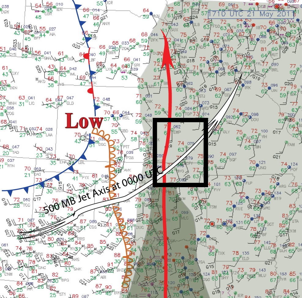
May 22: ne Oklahoma or north Texas? It's ne Oklahoma!

Next looking at the forecast soundings....the NAM has CIN for ne Oklahoma and very little CIN for the southern target...and the RUC has CIN holes in both locations. Looking at the forecast hodographs there would be no contest. ne Oklahoma has dramatic loops with nearly 30 knots of low level shear in both the NAM and RUC forecasts. Looking at those hodographs, I see the shear vectors nearly at right angles for 0-0.5 to 0.5 to 1.0 km!!!! There are dramatic turning of the shear vectors in the hodographs for the southern target too....but the deep layer shear is 36 knots (0-6 km) for the southern target and 46 knots for the northern target.
 By the way, the hodograph was the key to understanding some of what happened in ne KS yesterday. I am trying to get myself from just assuming that surface winds need to be southeasterly....they don't, because the hodograph is the key. A sw surface wind (wiht adequate CAPE) can give a wind profile favorable for rotating storms if all the winds are shifted to the right on the hodograph. Then the low level shear becomes important....as some found out and pointed out by action yesterday, outflow boundaries can augment the anemic low level shear profiles in some cases....clearly that's what happened in ne KS yesterday. Too bad I couldn't put my own actions behind those nice sounding words....!
Anyway, we have an hour or so before checkout, but our provisional target is very close by....Tulsa and northeast. The last plot at right shows the position of the cold front and dryline this morning and projected for this afternoon.
The white arrow shows the jet stream's position this projected for this afternoon, and the red arrow represents the axis of the tongue of high dew points and CAPE for this afternoon. The green shading shows dew point contour channels starting with 60F, then 65 and 70F. The semi-transparent cold front and dryline indicates the forecast position of the dryline and cold front this afternoon. It's been a while since we've chased a very very high CAPE pattern that also has favorable shear.

May 21, 2011
May 21: Convective Initiation Soon....and Giving Up Too Soon

And they explosively developed, as we watched, just west of Emporia, KS. But, during the 45 minutes or so we watched...the anvils became diffuse, the radar presentation was not convincing, so we decided to drop south to our overnight location in Perry, Oklahoma, since our initial target on Sunday appears to be the Red River area around Wichita Falls TX.
Alas, the storm, as it approached Topeka in northeastern KS became an intense supercell. As much as we can make of it from the radar information, it must have crossed over a boundary, because it really suddenly developed a hook, and had Tornado Vortex Signatures consistently for the next hour. Some video we were able to see indicated some very well defined funnels associated with it. I'm trying to communicate with some colleagues who stayed with the storm to see what kind of tornadoes (and if tornadoes did indeed occur).
May 21: Into Southeastern KS
 What we see (from the RUC) for this afternoon are soundings with very little CIN and ~3000 J/kg around Independence, KS, for example. Yes, the surface winds are not forecast to be southeasterly, but it turns out that south southwesterly winds actually give a very good hodograph (see right, for Independence KS this afternoon). That anticyclonic loop is very dramatic between 0-3 km, with nearly 90 deg turning of the wind shear vector. The 0-1 km shear is nearly 30 knots! I don't see any evidence of weak shear, or unfavorable shear profiles and haven't for any runs of the models the last 12 hours. It's true that the NAM had some funky turning of the shear vectors for several regions in its 0000 UTC run, though.
It's hard for us to ignore 3000 J/kg and a favorable shear profile, just 100 miles or less from us today. I also think there will be action along the Red River tomorrow....so at least that area is in range, even if we get as far north as Emporia today. So our provisional target is centered near Independence, KS.
May 20, 2011
Preliminary Target for May 21--Southeastern Third of KS

There is a wedge of high dew point temperatures and CAPE, with, according to the WRF-NAM, little CIN, from southeast Oklahoma through extreme eastern KS to the northeastern third of Kansas....underneath very decent 500 mb flow. In fact, the surface wind to 500 mb crossover is forecast to be much better in those areas than the best we had today. So good, that the forecast 0-3 km SREH values are very enticing...where they are coextensive with the better instability values.
I plotted forecast soundings and hodographs for that area, and there are some striking anticyclonic loops in the lowest 3 km over se KS and up through the Topeka area...and also down into se Oklahoma. The soundings have a very steep lapse rate in the EML which explains why the forecast sbCAPE values are more striking for those areas tomorrow than the same surface temps and dew points produced today in parts of KS.
I think we'll be rargeting the area east of a Topeka-Emporia-Tulsa arc tomorrow afternoon. I'd rather not go down to the tropical rainforested hills of se Oklahoma, but I will if the pattern resolves out better in the morning models and obs; so that arc may spread south of Interstate 40.
Right now it's a go for us. The prospects seem much better in those areas tomorrow than anything we had today, and we saw interesting storm structure today.
Forming Wall Cloud--Three Storms, Briefly Supercells Probably


- Posted using BlogPress from my iPhone
Thom and I were drawn to the target in the vicinity of Pratt, as explained in our forecast posts. The first convective initiations produced a discontinuous line of multicells from near Russell to just south of Pratt. We holed up briefly in Great Bend, trying to see if the northern weak cyclone would develop some backed flow near I70, hoping to pull the 65F dewpoints back west...but that didn't happen.
But the weakly backed flow near Pratt was still ongoing, and we noted some tendency for the linear cells back there to break into more discrete ones. In fact, we saw three cells there that had supercellular structure characteristics. Each of them produced a lowering/wall cloud that briefly did not look shelfish...but mostly just looked like outflow features. But the few minutes for the first three storms that wall clouds developed there was some interesting structure...including inflow tails that extended far north as roll clouds, sculpted updraft towers, and some high-based, perhaps shear funnel clouds. Each wall cloud or lowering had only weak signs of rotation...and most of the time looked ragged. But one of those latter cases produced a feathery looking large lowering with blocky outline (but was not solid at all...imagine a bunch of feathers jammed together hanging downward and flaring outward).
We briefly dropped south to watch a fourth storm....but decided it was going to undergo the same fate ultimately. Actually, it did briefly look good on radar when we got to Hutchinson. But by that time we had committed to pulling in for the evening.
We weren't expecting much of this day...but frankly it was fun, and we saw some great storms and cloud features.
Organizing Supercell
Nice nontornadic

storm forming.....
- Posted using BlogPress from my iPhone
storm forming.....
- Posted using BlogPress from my iPhone
Location:View St,Oakland,United States
In Great Bend at 3:53PM CDT...
We are temporarily in Great Bend. We are now considering moving towards a vigorous cell that is showing signs of rotation now near Greensburg. The radar image included here is recent....the little icons on the roads are the position of other chasers.
A Mess of Storms Today: No Significant Focus, and Limited Tornado Potential
Thom and I are sitting in a grungy Ramada Inn in Salina. Right now we are thinking about the area southwest of Pratt into northwest Oklahoma this afternoon. As Roger points out, the deep layer shear is expected to be fine there this afternoon. I'm afraid that the low level shear looks very weak....but that is where the models suggest sort of a dry line bulge, perhaps a weak surface low to amplify surface flow. The CAPE field appears adequate. Not a very good setup, but it's what we have got to work with.
Complicating things a bit on a day that is already pretty much of a mess...is that the best forecast hodographs are around Topeka. But with lots of CIN left over from the day's convection. So that area is, of course, out.
I still like the area between Wichita and Pratt or so....the RUC shows that weak low in sw KS and nw Oklahoma. If we can get the winds to stay backed at the surface with some decent flow....then the very good 500 mb flow of 45 knots or so SW winds COULD yield a supercell or two. There are outflow boundaries sloshing around too that might add a focus and also a source of low level solenoidal vorticity that could be tilted into the updrafts.
There are so many CONS today, it's pointless to list them all. And it looks like there might be a sucker line of storms that develop early. Both the HRRR and RUC, with their high FAR,suggest isolated cells west of Pratt around 22 UTC or so, after that other line goes through.
Fortunately, we don't have to go far today, as we are currently in Salina. Right now, our target is around Pratt. But we might hang around a bit in Salina to see how the wind fields resolve.
May 19, 2011
Several energetic storms...
Thom and I got to Hays about the time that the tornadic storm north of Russell had a beautiful hook...but it was also moving into colder air. It was part of a discontinuous line of storms extending from north of I70 to about 40 miles south. There was a break in the line on I70, and our intent was to punch through to the other side and then drive north to either the first cell or the second one that now was tornado warned. But, the area filled in, and we had a half hour of driving through torrential rain....with the GRLevel signal dropping out, and also Mobile Threatnet missing every other scan. By the time we cleared the line...almost to 20 miles west of Salina, the first storm had croaked, and the second one was a gigantic HP mess.
 We kept our eyes on the Pratt area...because the bubbling cumulus field down there seemed sure to erupt. We stayed with it as it was producing strong mesocyclones and tornado warnings near LIncoln. We saw some supercellular structures embedded in the rain, but nothing too dramatic. We also dropped down to the next storm to cross I70....that developed a hook...and parked ourselves and stayed with the inflow notch for a half hour or so....but the inflow base looked ragged and never showed much sign of rotation. The radar image shown above shows the mesocyclones and the hook (as well as Mobile ThreatNet can depict it). The yellow range rings really are centered on the GPS location of our car (with the rings at 5 mile intervals). Note that we were in "the" location to witness any tornado....but it was not to be.
We soon gave up and dropped south to Salina. All in all, kind of a waste of the great potential this pattern had.
Onto west-central Kansas

Southwest KS is clearing out, and moisture is coming northward through Pratt towards Interstate 70, which we are on. The target is in that general area shown by the box on the surface chart to the right.
Onto the Great Plains

The hodograph also has large 0-1 km shear values.
More as time permits.

May 18, 2011
First Day Target --- More or Less Unchanged

As you can see from SPC's Day 2 Outlook, the area we are targeting is now within SPC's outlook range. The red area encompasses the area in which there is a larger than 30% probability that a severe thunderstorm will be within 25 miles of a point.
Also note the hatching. This indicates that within that area there is an enhanced probability that some of those storms can produce high-end severe weather events (EF2-EF5 tornadoes and/or Hail >2" diameter and/or sustained winds 74 mph or stronger).
Once tomorrow's convective outllook passes into the Day 1 range, they will be honing those risks. But, we feel that the greatest threat for tornadoes is from the western tip of that red area south through sw Kansas and into the extreme northwestern area of Oklahoma, given the buoyancy and shear fields. Some of the parameters related to rotation production in storms are at the extreme high end of their ranges (climatologically speaking) for that area, with the largest values in Kansas.
This means that we will have to get the car setup quickly. A lapstop stand with power inverter, three antennae (onboard radar, GPS, and cell phone amplifier) need to be immediately functional so that we can get data as we are driving...and we need to be driving quickly. That risk area looks close to Denver on the above map, but there's still at least 200 to 300 miles or more of driving we need to do to get into the target area close to initiation time, which is liable to be around 4PM local time.
May 16, 2011
Storm Chase Trip 2011 -- In to the Great Plains, May 19th
Well, it's hard to believe that a year has gone by....but here we are about three days before our trip into the Plains. The long range forecasts have been showing a favorable pattern for the first week or so of our trip.
 The first graphic here is the composite (average) of 500 mb weather patterns for similar weather maps at this time of year in the past....it shows a fairly dramatic trough in the far West, setting up a favorable jet stream pattern over the Plains.
The dates shown on this figure indicate the best matches from past years, by year and date. We won't try very hard to look at that, because some of those dates include some very significant tornado events.
We'll be posting each day, and probably on the fly during the day, as we can now post images via our cell phones, and we'll have live access to the web in the car. We're looking forward to this, our 26th storm chasing trip....gad...how time has flown. Meanwhile, Thom will be posting updates to his WildGeeseChase.org blog. That's the real story behind the scenes....
 The pattern on the day that we arrive in Denver, May 19th, is setting up nicely for some severe thunderstorms in north central and central KS. So our target will be the area from Salina back west to Hill City or so (of course, to be adjusted as approach the time of our departure). The map shows our target as a blue box, and you can see we will be at the intersection of a dry line, cold and warm fronts...often called a "triple point" by storm researchers.
 I have plotted a sounding and hodograph for the region between Hill City, KS and Salina for around 6PM CDT for Thursday. The red area shows the surface-based CAPE (the region where an ascending air parcel will be warmer than its surroundings and will freely loft). The hodograph is very interesting, as it shows that the low level wind shear will be quite strong, 20-30 knots underneath a very strong southewesterly jet. If this profile develops, then storms will rotate strongly, and the low level shear tells us that isolated storms are liable to become tornadic.

The dates shown on this figure indicate the best matches from past years, by year and date. We won't try very hard to look at that, because some of those dates include some very significant tornado events.
We'll be posting each day, and probably on the fly during the day, as we can now post images via our cell phones, and we'll have live access to the web in the car. We're looking forward to this, our 26th storm chasing trip....gad...how time has flown. Meanwhile, Thom will be posting updates to his WildGeeseChase.org blog. That's the real story behind the scenes....
 The pattern on the day that we arrive in Denver, May 19th, is setting up nicely for some severe thunderstorms in north central and central KS. So our target will be the area from Salina back west to Hill City or so (of course, to be adjusted as approach the time of our departure). The map shows our target as a blue box, and you can see we will be at the intersection of a dry line, cold and warm fronts...often called a "triple point" by storm researchers.
Subscribe to:
Posts (Atom)


